Processing Your Payment
Please do not leave this page until complete. This can take a few moments.
-
News
-
Editions
-
- Lists
-
Viewpoints
-
HBJ Events
-
Event Info
- 2024 Economic Outlook Webinar Presented by: NBT Bank
- Best Places to Work in Connecticut 2024
- Top 25 Women In Business Awards 2024
- Connecticut's Family Business Awards 2024
- What's Your Story? A Small Business Giveaway 2024 Presented By: Torrington Savings Bank
- 40 Under Forty Awards 2024
- C-Suite and Lifetime Achievement Awards 2024
- Connecticut's Health Care Heroes Awards 2024
-
-
Business Calendar
-
Custom Content
- News
-
Editions
View Digital Editions
Biweekly Issues
- April 29, 2024
- April 15, 2024
- April 1, 2024
- March 18, 2024
- March 4, 2024
- February 19, 2024
- February 5, 2024
- January 22, 2024
- January 8, 2024
- + More
Special Editions
- Lists
- Viewpoints
-
HBJ Events
Event Info
- View all Events
- 2024 Economic Outlook Webinar Presented by: NBT Bank
- Best Places to Work in Connecticut 2024
- Top 25 Women In Business Awards 2024
- Connecticut's Family Business Awards 2024
- What's Your Story? A Small Business Giveaway 2024 Presented By: Torrington Savings Bank
- 40 Under Forty Awards 2024
- C-Suite and Lifetime Achievement Awards 2024
- Connecticut's Health Care Heroes Awards 2024
Award Honorees
- Business Calendar
- Custom Content
UConn researcher maps COVID-19 spread by town using travel data
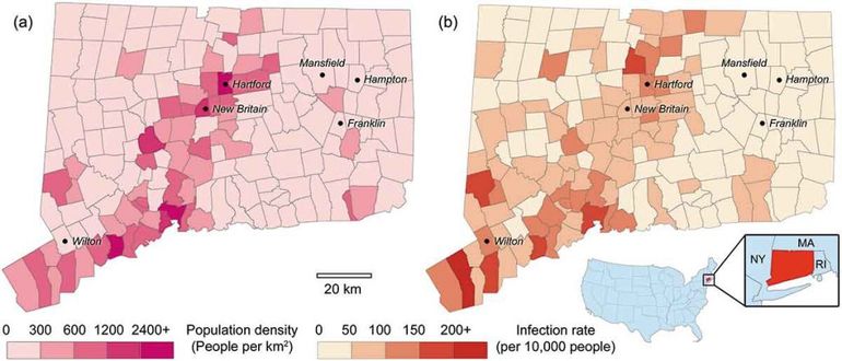
A UConn researcher and his collaborators have figured out how to predict how many COVID-19 cases are likely in specific Connecticut towns with a new model powered by travel data.
Geography Professor Peter Chen created a predictive model for COVID-19 in Connecticut based on travel distances and broken down by towns rather than states or counties.
Using state Department of Public Health data, Chen and his colleagues modified a traditional model for epidemic simulations and added in social distancing metrics and residents’ travel activities taken from survey data.
Due to travel bans and pandemic restrictions, most COVID-19 infections in Connecticut are being transmitted from town to town, according to the state data. The new model can help determine which towns are at higher risk and deploy resources to help.
“I think this will be very important not only to people at the Connecticut Department of Health managing resources and leveraging them to serve high-risk towns, but also on the local government level,” Chen said. “If they realize they have a high risk, they can be more cautious.”


2022 Giving Guide
This special edition informs and connects businesses with nonprofit organizations that are aligned with what they care about. Each nonprofit profile provides a crisp snapshot of the organization’s mission, goals, area of service, giving and volunteer opportunities and board leadership.
Learn more
Subscribe
Hartford Business Journal provides the top coverage of news, trends, data, politics and personalities of the area’s business community. Get the news and information you need from the award-winning writers at HBJ. Don’t miss out - subscribe today.
Subscribe
2024 Book of Lists
Delivering Vital Marketplace Content and Context to Senior Decision Makers Throughout Greater Hartford and the State ... All Year Long!
Read Here-
2022 Giving Guide
This special edition informs and connects businesses with nonprofit organizations that are aligned with what they care about. Each nonprofit profile provides a crisp snapshot of the organization’s mission, goals, area of service, giving and volunteer opportunities and board leadership.
-
Subscribe
Hartford Business Journal provides the top coverage of news, trends, data, politics and personalities of the area’s business community. Get the news and information you need from the award-winning writers at HBJ. Don’t miss out - subscribe today.
-
2024 Book of Lists
Delivering Vital Marketplace Content and Context to Senior Decision Makers Throughout Greater Hartford and the State ... All Year Long!
ABOUT
ADVERTISE
NEW ENGLAND BUSINESS MEDIA SITES
No articles left
Get access now
In order to use this feature, we need some information from you. You can also login or register for a free account.
By clicking submit you are agreeing to our cookie usage and Privacy Policy
Already have an account? Login
Already have an account? Login
Want to create an account? Register
0 Comments